|
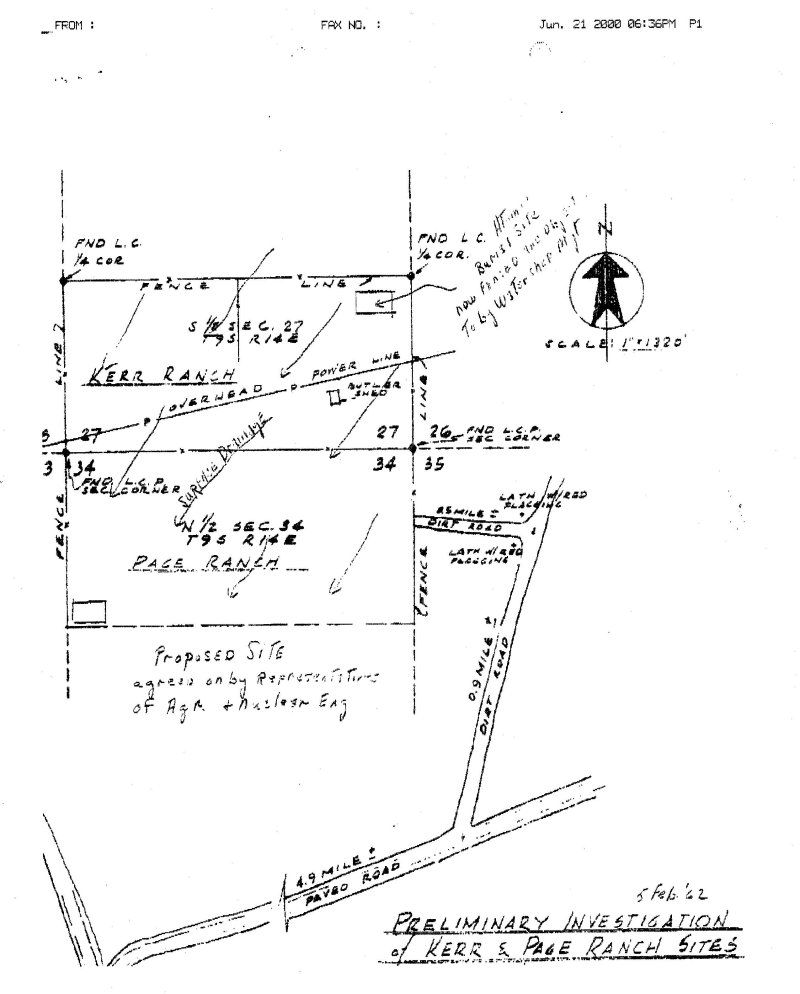
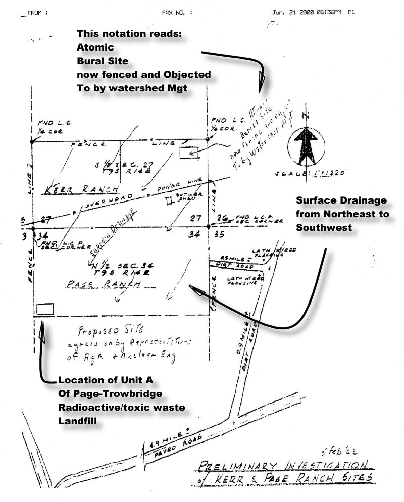
by J.C. Huntington Dateline: Florence Arizona, November 1, 2000 Posted to PoisonedWells November 7, 2000 Updated November 9, 2000 The University of Arizona owns a mile square section of land that houses the current Page-Trowbridge radioactive/toxic waste landfill. The U of A has consistently maintained that there was no disposal of radioactive waste in the area prior to 1962. While maintaining that there had been no disposal of radioactive waste in the area prior to 1962, in 1995 the U of A acknowledged that there was "some isolated prior use" of Page Ranch for disposal of radioactive waste The map The map was illegally withheld by the U of A from an Oracle resident in response to a Public Records request, then later released when the U of A admitted that they had not furnished all records in response to the Public Records Request. The map shows the square mile section of land that houses the current Page-Trowbridge radioactive/toxic waste landfill. The location of Unit A, supposedly the oldest disposal area at the current Page-Trowbridge site, has been penciled in the southwest corner of the section. The 1962 map calls this area a "Proposed Site". Another area called an "Atomic Burial Site" is shown on the 38 year old map approximately one and a half miles from the current Page-Trowbridge landfill.
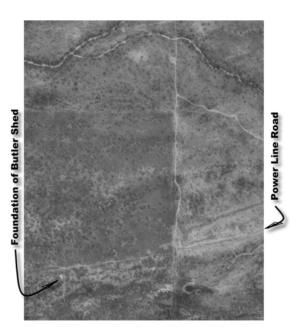
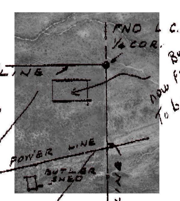
Also shown on the map is a rectangle labeled "Butler Shed". Butler
is a company that manufactures metal building systems which are frequently
used as sheds. An old concrete foundation now stands at this location.
The foundation is large, about the size of a two car garage. At one
end of the foundation is a ramp that would allow trucks to back into the
shed and deposit containers.
Some questions raised by the map Questions raised by the map include:
In addition to the map, the other documents from the U of A archive indicate that extensive experimentation with radioactive material was underway as early 1960, at least two years before the U of A officially disposed of nuclear waste in area of Page-Trowbridge. A document dated 1960, some two years before the Atomic Energy Commission allowed nuclear waste to be disposed of at Page Ranch, shows that there were at least 14 active projects involving radioactive material at the U of A. This finding raises the question of "was the radioactive waste from these 1960 projects disposed of at the 'Atomic Burial Site' shown on the map?" If the answer to that question is "no", then there is nothing to be concerned about. If the answer to the above question is "yes", then there is completely unregulated radioactive waste laying in the desert about a mile and a half northeast of the Page-Trowbridge radioactive/toxic waste landfill. Surface drainage Arrows on the map show surface draining going from the northeast to the southwest. A notation on the map indicates that the area called an "Atomic Burial Site" was objected to by Watershed Management. A clear implication of the surface drainage direction and the objection by Watershed management is that the surface drainage would carry radioactive contamination across the section of land owned by the U of A. If this implication is true, it is likely that the same surface drainage would carry radioactive contamination from Page-Trowbridge known to be at Page-Trowbridge on to adjacent land to the southwest of the U of A property, where the proposed SaddleBrooke Ranch development will lie. Images
of the map are repeated below:
Discovery of the map The U of A did not initially release the map in response to a Public Records Request made by Web Parton, an Oracle resident who researched the history of the Page-Trowbridge radioactive/toxic waste landfill in response to a request from the Oracle Town Hall. During research for his report, Parton filed a public records request with the Custodian of Public Records at the U of A requesting any and all documents pertaining to radiation disposal at Page Ranch. The universitie's Custodian of Public Records is reponsible for accounting for all public records at the U of A. In response to his request, Parton received only two documents, and was told by the U of A that these documents were the complete set of documents pertaining to radiation disposal in the Page Ranch area. The map and several other documents relating to radiation use at the U of A were not among the documents originally released to Parton. The existence of the missing documents came to light during an Oracle Town Hall meeting in November of last year called to address the threat of Page-Trowbridge to the local water supply. At that meeting, Parton displayed the two documents he had received from the U of A in response to his request, and told the audience that these two documents was the totality of the records that the U of A had regarding of radioactive material at Page-Trowbridge. At that point Mel Young, Director of Radiation Control at the U of A, rose to his feet and corrected Parton, telling Parton and the assembled citizens that other documents related to radiation existed. A video tape of the meeting shows that Parton was somewhat taken aback by the revelation that documents had been withheld from him. The tape shows Parton asking for an explanation of why he was not given all documents regarding disposal of radioactive material at Page Ranch per his Public Records Request. Steve Holland, Director of the U of A Risk Management and Safety Department, then explained that several documents pertaining to radioactive disposal at Page Ranch had not been released to Parton due to what Holland called "a misunderstanding". Holland explained that Parton's Public record request had been misinterpreted by the University in such a way that the University believed that the request pertained only to documents in possession of the U of A Risk Management Department and that the documents in question were held by the Radiation Control Office, headed by Young. Niether Holland nor Young explained how the U of A's Custodian of Public Records had made this error. Holland and Young then agreed to make the documents available to Parton. Parton received the previously withheld documents a week later. When later asked by the Arizona Daily Star why the U of A had not provided all documents to Parton in response to Parton's request, Holland said that, "we couldn't go running all over campus looking for documents". Parton told the Arizona Daily Star that the U of A "lied and broke the law" when they withheld the documents from him. Pinal County Board of Supervisors informed Parton informed the Pinal County Board of Supervisors of his findings at a public hearing held November 1 to consider a rezoning request by Robson Communities Inc. The supervisors expressed little interest and asked no questions. At that hearing, the Supervisors approved a rezoning request to allow 6,000 homes, a commercial center and several golf courses to be built on land adjacent to Page-Trowbridge. |
||||||||||||||
|
The images below show an
aerial view of the northwest corner of the section of land that contains
the "Atomic Burial Site". One image has a portion of the map overlaid
and the other does not.
|
|||||
|
Only two samples were tested. Eight samples, including 3 red tailed hawks are still missing. Hawks are top carnivores; if the hawks had been feeding on animals contaminated with radioactive material, the radioactive contamination would accumulate in the hawk's organs and tissues. Analysis of the hawks organs and tissues could have provided invaluable evidence to confirm or deny the existence of of radioactive contamination in the Page-Trowbridge area. Unfortunately, this evidence has gone missing and is still missing after more than twenty years. A synopsis of the missing evidence may be read by clicking here. |
Use
The 'Back' Button On Your Browser
To
Return To Previous Page
News
& Information
Introduction
![]()
![]() email:mekazda@mindspring.com
email:mekazda@mindspring.com