 |
|
|
|
|
|
|
Less than 1 month into the review period, Pinal County has revised it's Comprehensive Plan Posted to PoisonedWells.com October 16, 2001
From: <jc_huntington@PoisonedWells.com> To: "Dennis Cady" <Dennis.Cady@co.pinal.az.us> Cc: "Anne C Graham-Bergin" <AGraham@ravlaw.com>; "Jimmie Kerr" <Jimmie.Kerr@co.pinal.az.us>; "Lionel Ruiz" <Lionel.Ruiz@co.pinal.az.us>; "Sandie Smith" <Sandie.Smith@co.pinal.az.us>; "Stan Griffis" <Stan.Griffis@co.pinal.az.us>; "Heather Urquides" <heather.urquides@arizonarepublic.com>; "Pedersen, Hans" <hpedersen@kold.com>; "Tony Davis" <verdin@azstarnet.com>; "Casa Grande Valley Newspapers" <dispatch@casagrande.com>; "Northwest Explorer" <news@explorernews.com>; "San Manuel Miner" <path@copperarea.com>; "Kari Redfield" <kar_red@yahoo.com>; "Robert Carter Olson" <Carter.Olson@co.pinal.az.us> Subject: Re: Pinal County Comprehensive Plan On Web Site Date: Tuesday, October 16, 2001
8:59 AM
Dear Mr. Cady, As you know, I asked you yesterday via email why the Pinal County Comprehensive Plan, originally published for the final review on the Pinal County web site on October 2, 2001, was unavailable on the Pinal County web site as of October 15, 2001. After you told me that an error MIS department had made the copy of the Pinal Comprehensive Plan unavailable to the public (see your email below), I went to the Pinal County home page (http://www.co.pinal.az.us/). I found that the version of the Pinal Comprehensive Plan published on the Pinal County web site on October 15, 2001 is different from the version of the Pinal Comprehensive Plan published on the Pinal County web site on October 2, 2001. I know the versions are different because I saved both the Original Version and the New Version on my local disc. I am disappointed that in your response to me, you falsely implied that the version of the Pinal Comprehensive Plan published on October 15, 2001 was the same as the version published October 2, 2001. Here is a copy of your email with emphasis supplied, my annotation in [brackets] (your original response is also attached below):
For
the purpose of this note, I'll call the version of the Pinal County Comprehensive
Plan published on the Pinal County Web site on October 2, 2001, the "Original
Version" of the Pinal Comprehensive Plan (the Plan), and the version of
the Pinal County Pinal County Comprehensive Plan published on the
Pinal County Web site October 15, 2001, the "New Version" of the Plan.
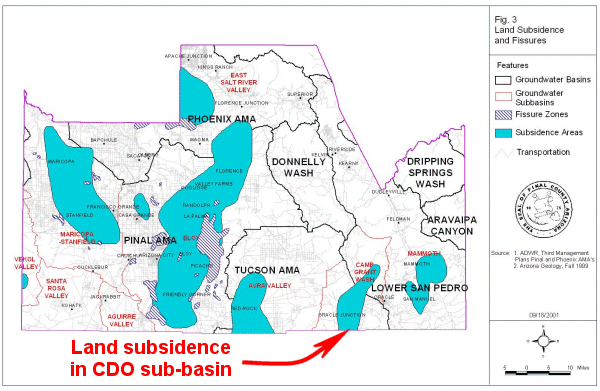
One
difference between the two versions is that the Land Subsidence Map has
been altered in the New Version.
The
copy of Pinal's Land Subsidence Map in the Original Version of the Plan
showed a wide swath of land subsidence that running directly under the
Page-Trowbridge radioactive/toxic waste landfill.
The
figure below is a copy of the Original Land Subsidence Map with annotation
added to call attention to the land subsidence in the eastern part of the
Tucson AMA. (I can supply you with the original copy sans the annotation
if you need one):
|
 |
|
On
October 9, I published an analysis based on the Land Subsidence map published
in the Original Version of the Plan and emailed you the URL to allow you
access to the analysis (http://www.poisonedwells.com/news/2001_10_09/news_1.htm).
As you know, the analysis, based on the land subsidence in the eastern part of the Tucson AMA, found that importing nearly 190,000 people to Area 4-B, as authorized by the Plan, could put the public health and financial well being of local residents in jeopardy. On
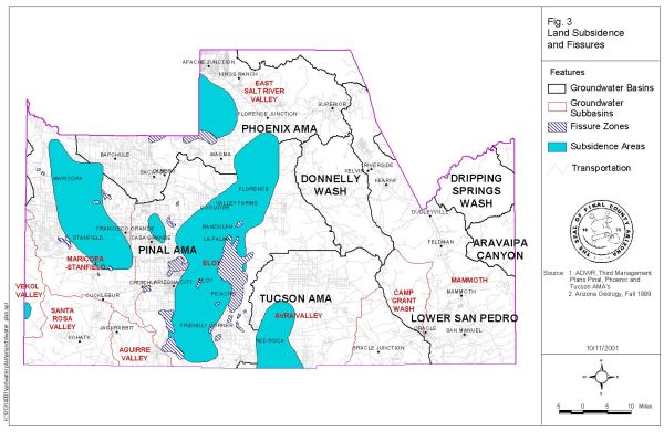
October 15, some 6 days after you received the analysis, Pinal County published
the New Version of the Plan. The swath of subsidence in the eastern
part of the Tucson AMA has been deleted from the Land Subsidence Map in
the New Version of the Plan.
Here
is a copy of the Land Subsidence map from the New Version of the Plan:
|
 |
|
You
need to explain why the area of land subsidence in the eastern portion
of the Tucson AMA, shown in the Original Version of the Plan was deleted
from the New Version of the Plan.
Specifically:
1.. What data was used to make the Land Subsidence map published in the
Original Version of the Plan?
2.. What data was used to alter the Land Subsidence map published in the
New Version of the Plan?
3.. When was the change made?
4.. Who authorized the change to the Land Subsidence map?
5.. Were any other alterations made to the Original Version of the Plan?
6.. If so, who authorized these alterations?
7.. If so, what data was used to make the Original Version of the Plan
and what data was used to make the changes (if any) in the New Version
of the Plan?
8.. Are any further changes to the Pinal Comprehensive Plan expected?
------- The cover page of the New Version of the Plan is misleading and false. Specifically: The cover page for the Original Version of the Pinal County Comprehensive Plan published on the Pinal web site October 2, 2001 contains this text: On September 27, 2001, the Pinal County Planning & Zoning Commission approved this Proposal for transmittal pursuant to A.R.S. § 11-806G)The cover page for the New Version of the Pinal County Comprehensive Plan published on the Pinal web site October 15, 2001 contains exactly the same text: On September 27, 2001, the Pinal County Planning & Zoning Commission approved this Proposal for transmittal pursuant to A.R.S. § 11-806G) Since
the Original Version of the Plan is different than the New Version of the
Plan, and since the Original Version of the Plan was approved by the P&Z
Commission on September 27, 2001, the P&Z Commission could not have
also approved the New Version of the Plan on September 27, 2001.
A.R.S. § 11-806G states
(emphasis supplied):
G. At least sixty days before the comprehensive plan or a portion, element
or major amendment of a comprehensive plan is adopted, the commission
shall transmit the proposal to the board of supervisors and
submit a copy for review and further comment to:
1. Each municipality in the county.
Did
the Pinal Planning & Zoning Commission transmit the New Version of
the Plan in conformance to A.R.S. § 11-806G?
If
so, when was the New Version of the Plan presented to the P&Z Commission?
Were
the following items explained to the P&Z Commission:
1.. What data was used to make the Land Subsidence map published in the
Original Version of the Plan?
2.. What data was used to alter the Land Subsidence map published in the
New Version of the Plan?
3.. When was the change made?
4.. Who authorized the changes to the Land Subsidence map?
5.. Were further alterations (if any) explained to the Commission?
If the P&Z Commission has not yet transmitted the New Version of the Plan pursuant to A.R.S. § 11-806G, will the commission be presented with the New Version of the Plan at the their public meeting scheduled for October 18? If so, do you plan to answer the above questions for the Commissioners? As
to the special meeting to review the Water Resources Element of the Plan
tomorrow evening at the BHP Conference Room in San Manuel:
Please
bring several copies of all the source data used to create the Land Subsidence
Map published in the Original Version of the Plan as well as several copies
of all the source data used to create the altered version of the Land Subsidence
Map published in the New Version of the Plan.
Please be prepared to answer the above questions. Please be prepared to explain why you falsely implied that the version of the Pinal Comprehensive Plan published on October 15, 2001 was the same as the version published October 2, 2001 in your email response to me dated October 15 (copy follows). Warm regards,
J.C. Huntington
----- Original Message ----- From: Dennis Cady
To: jc_huntington@PoisonedWells.com
Cc: Jimmie Kerr ; Lionel
Ruiz ; Sandie Smith ; Stan Griffis
Sent: Monday, October
15, 2001 11:29 AM
Subject: Pinal County
Comprehensive Plan On Web Site
The Pinal County home page again
provides clear access to the Comprehensive Plan. The MIS department inadvertently
relocated it under the Department Link when the updated it Friday. They
have corrected it. It is now located as before with a clear link on the
home page for Pinal County. Thank you for bringing it to our attention.
Dennis Cady
|
Back
to News & Information
Back
to Introduction
![]()
![]() email:mekazda@mindspring.com
email:mekazda@mindspring.com